|
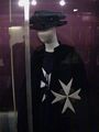
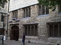
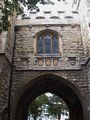
Location of St John - Priory of Order of St John of Jerusalem
Other links to St John - Priory of Order of St John of Jerusalem
Restaurants in the area
Club Gascon (distance = 425 m bearing 122°)
, Coach and Horses (distance = 421 m bearing 326°)
, Eagle (distance = 261 m bearing 221°)
, FishShopThe (distance = 184 m bearing 301°)
, Smiths of Smithfield (distance = 334 m bearing 212°)
, St. John (distance = 123 m bearing 129°)
, Vivat Bacchus (distance = 345 m bearing 327°)
Local Pubs
Barley Mow (distance = 373 m bearing 131°)
, Bishop's Finger (distance = 392 m bearing 121°)
, Bleeding Heart (distance = 429 m bearing 222°)
, Butchers Hook and Clever (distance = 376 m bearing 122°)
, Hand and Shears (distance = 399 m bearing 129°)
, Hope (distance = 228 m bearing 213°)
, Rising Sun (distance = 396 m bearing 130°)
Nearby sights
Old Booths Distillery (distance = 171 m bearing 121°)
, Finsbury Bank (distance = 383 m bearing 305°)
, Johnson Building - 77 Hatton Garden (distance = 477 m bearing 232°)
, St John's Gardens (distance = 137 m bearing 223°)
, Charterhouse (distance = 257 m bearing 145°)
, St Bartholomew the Great (distance = 425 m bearing 129°)
, St Bartholomew The Less (distance = 492 m bearing 123°)
, St James Clarkenwell (distance = 276 m bearing 317°)
, Woodbridge Chapel (distance = 250 m bearing 307°)
, Middlesex Session House (distance = 284 m bearing 327°)
, Smithfield (distance = 317 m bearing 123°)
, Golden Boy (distance = 477 m bearing 122°)
, Prodtestant Martyrs (distance = 436 m bearing 126°)
, Marx, Karl - Library (distance = 262 m bearing 323°)
, Wallace, Sir William (distance = 436 m bearing 126°)
, Charterhouse Square (distance = 193 m bearing 142°)
, Clarkenwell (distance = 154 m bearing 304°)
, Clarkenwell Green (distance = 241 m bearing 325°)
, Hatton Garden (distance = 437 m bearing 232°)
, Smokehouse Yard (distance = 142 m bearing 138°)
, St John Street (distance = 61 m bearing 145°)
, St Johns Square (distance = 115 m bearing 301°)
Nearby Neighbours (Plaques)
GROOM, John (1845-1919), (distance = 203 m bearing 311°)
, MAXIM, Sir Hiram (1840-1896), (distance = 338 m bearing 237°)
Notorious sights in the area
Charterhouse - Plague Graveyard (distance = 276 m bearing 139°)
, Execution Site - Smithfield (distance = 362 m bearing 123°)
, Peasants Revolt (distance = 436 m bearing 121°)
, Saffron Hill - Slum (distance = 360 m bearing 233°)
, Tyler, Wat - plotter Execution (distance = 471 m bearing 124°)
General Links Local Map
Map of what is in the area - using Google map
|